The following workshops have been scheduled for Sunday, 7 September 2025
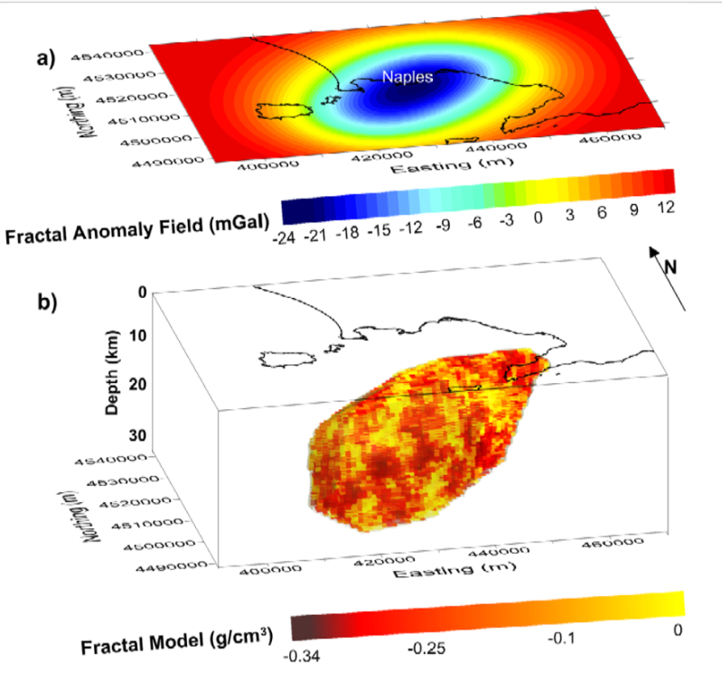
Geophysical Exploration in Volcanological Areas: Imaging Challenges and Public and Operational Constraints
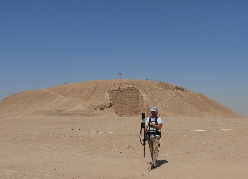
Geophysical applications to archaeology: innovation in acquisition and data modelling.
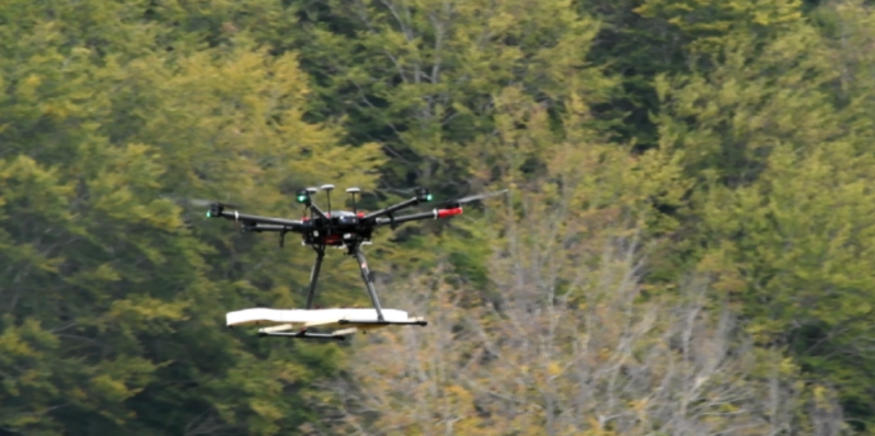
Airborne Geophysics: advances and perspectives from different platforms.
Please note:
Badge pick up and registration for the workshops is available directly at the Hotel Renaissance Mediterraneo, as of Sunday, 7 September, 08:00 AM.
Date:
3 Sep 2023
Time:
09:00 - 15:00 BST (TBC)
Convenors
Joanne Kwan (CIRIA)
Charlotte Usher (RSK Geophysics)
The construction industry research and information association (CIRIA) is a neutral, independent body in the UK set up to provide guidance and knowledge sharing for the construction industry. Based on the CIRIA research proposal (RP) 1146, the lead contractors RSK alongside a project steering group have been working on updating the C562 standard, published in 2002, to demonstrate good practice on the use of geophysics in ground investigations to be finalised in 2023. This workshop could be used to present the new standards for geophysical support of ground investigations.
Guidance objectives
| Preliminary Schedule | |
|---|---|
| 00:00 | Lorem ipsum dolor sit amet, consectetur adipiscing elit. Praesent scelerisque rhoncus magna at condimentum |
| 00:00 | Lorem ipsum dolor sit amet, consectetur adipiscing elit. Praesent scelerisque rhoncus magna at condimentum |
| 00:00 | Lorem ipsum dolor sit amet, consectetur adipiscing elit. Praesent scelerisque rhoncus magna at condimentum |
| 00:00 | Lorem ipsum dolor sit amet, consectetur adipiscing elit. Praesent scelerisque rhoncus magna at condimentum |
Date:
7 Sep 2025
Time:
09:00 -17:00 CEST (subject to change)
Room:
Available soon!
Convenors:
Pier Paolo Bruno (Università degli
Studi di Napoli Federico II)
Paola Ragazzo (Eni)
Overview
Volcanological areas present a unique challenge for geophysical exploration due to their highly heterogeneous subsurface structures, complex fluid-rock interactions, and dynamic temporal evolution. Traditional seismic inversion techniques often struggle to resolve the intricate nature of these environments. However, advances in both passive and active seismic data inversion— along with joint inversion methodologies incorporating other geophysical techniques—offer new insights into subsurface imaging in these complex settings.
This workshop will focus on the latest methodologies for geophysical inversion in volcanological areas, emphasizing both active source and ambient noise (passive) seismic data. Additionally, we will explore joint inversion approaches that integrate seismic, gravity, electromagnetic, and other geophysical datasets to enhance our understanding of volcanic systems.

Key Topics
• Seismic inversion in volcanic environments: Challenges and advancements in active and passive seismic techniques.
• Joint inversion strategies: Combining seismic with other geophysical methods (e.g., gravity, magnetotellurics, electrical resistivity) for improved imaging.
• Fractal density and subsurface complexity: Volcanic structures often exhibit self- similar, scale dependent heterogeneity, akin to fractal geometry. How can inversion techniques account for and leverage this fractal nature?
• Case studies from the Phlegraean Fields and other active volcanic regions: Applications of modern inversion techniques to improve subsurface characterization.
• Future directions in geophysical exploration of volcanological areas: New technologies and methodological approaches.
• Public Communication & Risk Perception: Build effective plans to engage local communities to ensure acceptance of geophysical studies; lessons from past.
Participant Profile
This workshop will bring together researchers and industry professionals to discuss cutting- edge developments in geophysical exploration and inversion techniques tailored to the complexities of volcanic settings.
| WORKSHOP SCHEDULE | |
|---|---|
| 9:00 | Welcome & Introduction to the Workshop |
| 9:15 | |
| 10.00 | Break |
| 10:30 | |
| 11:00 | |
| 11:30 | |
| 12:00 | Lunch |
| 13:00 | |
| 14:30 | Break |
| 15:00 | |
| 17:00 | End of Workshop |
Date:
Sunday, 7 Sep 2025
Time:
09:00 -14:00 CEST
Location:
Renaissance Naples Hotel Mediterraneo
Via Ponte di Tappia, 25, 80133 Napoli NA, Italy
Convenors
Pier Paolo Bruno (Università degli
Studi di Napoli Federico II)
Paola Ragazzo (Eni)
Overview
Volcanological areas present a unique challenge for geophysical exploration due to their highly heterogeneous subsurface structures, complex fluid-rock interactions, and dynamic temporal evolution. Traditional seismic inversion techniques often struggle to resolve the intricate nature of these environments. However, advances in both passive and active seismic data inversion – along with joint inversion methodologies incorporating other geophysical techniques – offer new insights into subsurface imaging in these complex settings.
This workshop wants to be a deep dive into seismic data opportunities and challenges using Campi Flegrei area as a case study. Public consensus and the latest methodologies for geophysical inversion in volcanological areas, emphasising both active source and ambient noise (passive) seismic data will be explored.
Additionally, we will explore joint inversion approaches that integrate seismic, gravity, electromagnetic, and other geophysical datasets to enhance our understanding of volcanic systems.

| Preliminary Schedule | |
|---|---|
| 09:00 | Welcome and brief introduction to the objectives of the workshop |
| 09:10 | Mauro Di Vito (INGV-OV): "The Phlegraean Fields caldera: historical unrest, structural complexity, and current state of knowledge based on decades of monitoring and observations" |
| 09:35 | Francesca Bianco (INGV): "Geophysical exploration in the Phlegraean Fields: subsurface complexity, limitations of past investigations, and the need for high-resolution imaging" |
| 10:00 | Coffee Break |
| 10:15 | Civil protection strategy in the Phlegraean area: emergency scenarios, evacuation planning, alert levels, and institutional preparedness |
| 10:35 | Roberto Bossi (Eni): "Onshore vs Offshore Exploration: constraints and challenges in a socially and environmentally sensitive area" |
| 11:00 | Step 1: Groups discuss strategies & challenges |
| 12:00 | Lunch Break |
| 13:00 | Step 2: Each group presents their key findings |
| 13:30 | Step 3: Convenors lead a final summary discussion |
| 14:00 | Workshop ends |
Date:
Sunday, 7 Sep 2025
Time:
09:00 -17:00 CEST
Location:
Renaissance Naples Hotel Mediterraneo
Via Ponte di Tappia, 25, 80133 Napoli NA, Italy
Convenors
Federico Cella (Università di
Camerino)
Chiara Colombero (Politecnico di Torino)
Maurizio Milano (Università degli
Studi di Napoli Federico II)
Overview
We warmly invite researchers and enthusiasts in archaeogeophysics to join this workshop, a dynamic event for hands-on data processing, knowledge sharing, and exploration of the latest methodological advances in the field.
The workshop is specifically designed as an interactive experience to encourage active participation and provide an overview of the current state of art, challenges and advancements in archaeogeophysics.
Engage in critical discussions, challenge interpretations and contribute to pushing the boundaries of this research field together. Bring along your knowledge, laptop, favourite or innovative processing tools, and, if you like, your own data to showcase your research…
Dive into archaeogeophysics data processing and interpretation!

| Preliminary Schedule | |
|---|---|
| 09:00 | Welcome and introductory session - Short presentations on methodological advancements and challenges in data analysis, processing and interpretation of geophysical data for archeological prospection. |
| 10:15 | Coffee Break |
| 10:30 | Data Analysis - Different raw data sets for archaeological prospection will be made available to the participants (grav, mag, EM, GPR and ERT). The participants are asked and encouraged to spend this session processing and interpreting the data with their own laptops and tools. Participants can also/alternatively bring their data sets for showcasing and comparing the results. Knowledge sharing and critical discussions are welcomed during the session. |
| 13:00 | Lunch Break |
| 14:00 | End of data analysis & preparation to the discussion section |
| 15:00 | Coffee Break |
| 15:30 | Discussion section - The results of data analysis/processing of each data set will be gathered, presented and discussed. This session aims to summarise the advantages and limitations of the various approaches, provide a comprehensive data interpretation, identify unresolved issues, and outline future research directions in archaeogeophysics. |
| 17:00 | End of workshop |
We invite you to actively participate in the workshop programme by submitting a short presentation (maximum 10 minutes, in *.pptx or *.pdf format) to the convenors at federico.cella@unicam.it, chiara.colombero@polito.it, and maurizio.milano@unina.it.
This is a valuable opportunity to present and discuss your work on key topics in archaeogeophysics with fellow experts and enthusiasts.
Date:
Sunday, 7 Sep 2025
Time:
09:00 -17:00 CEST
Location:
Renaissance Naples Hotel Mediterraneo
Via Ponte di Tappia, 25, 80133 Napoli NA, Italy
Convenors
Massimo Chiappini (Istituto Nazionale di Geofisica e Vulcanologia)
Gianluca Fiandaca (University of Milano "La Statale")
Andrea Viezzoli (Emergo)
Overview
Airborne Geophysics is a fast-growing, discipline expanding the range of possible solutions to geophysical data acquisition. Drones, but also the more classical helicopters and fixed wing planes, they all are currently very busy acquiring data around the world, at different scales, for different applications.
This workshop focuses on all main geophysical techniques. We will look into advances in data acquisition, integration, processing and modelling. A part of the workshop will be highly interactive, with a live demo on AEM data processing and modelling, using open source software. The field of applications includes geologic mapping, environmental geophysics, hydrogeophysics, mining and resource exploration.
The participants will gain a complete overview of different airborne geophysical applications and insights into new developments, trends, and open problems.

| Preliminary Schedule | |
|---|---|
| 09:00 | Welcome and introductory session: airborne geophysics at different scales and with different platforms |
| 09:15 | Airborne Mag and FTMG |
| 09:50 | Airborne Grav: methodoly and case studies |
| 10:20 | Passive AEM: methodology and case studies |
| 10:50 | Coffee Break |
| 11:05 | Semiairborne EM systems: methodology and case studies |
| 11:35 | Helicopter EM systems: methodology and case studies |
| 11:50 | Fixed Wing EM systems: methodology and case studies |
| 12:20 | Details on AEM data processing and Modelling |
| 13:00 | Lunch Break |
| 14:00 | Live, hands on demo on AEM data processing and modelling |
| 15:10 | An interactive environment digging into potential field anomalies |
| 15:35 | Coffee Break |
| 15:50 | Unmanned airborne magnetic surveying: recent developments and the way forward |
| 16:15 | Integrating Airborne Geophysics with other info |
| 16:45 | Discussion: where is Airborne Geophysics heading ? |
| 17:00 | Workshop ends |
Date:
8 Sep 2024
Time:
09:00 - 17:00 EEST
Room:
TBC
Convenors:
Risto Kiuru (Rock Physics Finland Ltd, Finland )
Tuija Luhta (Geological Survey of Finland, Finland)
Workshop description
To fully understand and properly calibrate geophysical models, information on the physical properties of the rock mass is essential. Traditionally, literature and research on the topic has been quite heavily biased towards soft sedimentary environments. We propose a workshop on research and applications of rock and mineral physics in hard rock environments, specifically in the context of mineral exploration, mining and rock construction. Topics covered could include, e.g., laboratory testing of the physical properties of rocks and minerals, in situ physical property measurements, and application of physical property data to the development, calibration and interpretation of geophysical data and physical property models.
Participant profile
Draft schedule
10:00-13:00 On the first half of the workshop, convenors will present a compact introduction into rock and mineral physics, laboratory testing and further use of the data for those less familiar with the subject.
13:00-14:00 Lunch break
14:00-17:00 On the second half of the workshop, select participants will present their latest research and case studies. Adequate time will be reserved for discussion.
Date:
0-0 Month 2023
Time:
00:00 - 00:00 est
Convenors
John Doe (Company name)
Jane Doe (Company name)
Lorem ipsum dolor sit amet, consectetur adipiscing elit. Praesent scelerisque rhoncus magna at condimentum. Nam arcu nibh, fringilla ac hendrerit in, ullamcorper at lectus. Etiam semper a augue sit amet porttitor. Nunc bibendum maximus eros, in tristique eros bibendum et. Nulla metus lectus, pulvinar vitae lacus vel, dignissim pellentesque quam. Nam vehicula convallis leo, nec porta magna blandit in. Nam in orci a ligula egestas posuere. Vestibulum cursus mi est, vitae ullamcorper nisi porta non. Pellentesque consectetur mollis cursus.
| Preliminary Schedule | |
|---|---|
| 00:00 | Lorem ipsum dolor sit amet, consectetur adipiscing elit. Praesent scelerisque rhoncus magna at condimentum |
| 00:00 | Lorem ipsum dolor sit amet, consectetur adipiscing elit. Praesent scelerisque rhoncus magna at condimentum |
| 00:00 | Lorem ipsum dolor sit amet, consectetur adipiscing elit. Praesent scelerisque rhoncus magna at condimentum |
| 00:00 | Lorem ipsum dolor sit amet, consectetur adipiscing elit. Praesent scelerisque rhoncus magna at condimentum |